
West Branch of the Susquehanna
June 2006
Susquehanna River Trail
Map & Backround of The River Trail
Water is in my blood. At age 40, I made a journey to the West Branch, searching for the beginning of the river that flows near my home. The trek took me to beauty that few Pennsylvanians have ever seen and a 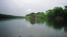 better understanding of the lethal legacy that a burgeoning country left behind.
I've often found when strangers paddle together it makes for great adventures. Last year, I met John Besecker on a canoe outing in the Adirondacks Around the campfire he mentioned that he wanted to paddle the entire Susquehanna and I told John that I was interested. He was to retire the next spring and as a teacher I have my summers off. After the Adirondacks, we scarcely keep in touch, but always keep the dream of paddling the river alive.
John and I started out on our 132 mile journey at Karthaus, Pennsylvania in seventeen foot aluminum Grumman canoe. Our gear included a propane cook stove, tent, a couple five gallon buckets of food, cook set, sleeping bags, change of clothes, personal items, and water safety gear. At the put in at Karthaus, we were greeted with warning signs of nude bathers. Luckily the weather was cool and the bathers were not out. Fantasies of nude bathers are often destroyed by the reality of rotund middle aged Homo sapiens.
The West Branch of the Susquehanna at this point was clear, swift and cool. Rocks were strewn throughout the river, causing eddies and swirling currents. Not white water, but water hurried on a gradual descent with boils and pillows abound. It had been several years since I had paddled a tank like the Grumman. I had grown comfortable with the responsiveness of my white water kayaks. I had forgotten that canoes were slow and inflexible beasts that needed to be paddled for future planning. Within the first 200 yards, I saw a weir channeling most of the current left. Believing we had plenty of time, I didn't warn John, the captain at the stern about the hazard until we were upon it our craft became offensively unbalanced and I made a split second decision to jump out of the boat so not to swamp our canoe. I was soaked, but safe. This was the West Branch's official welcoming and a quick paddling lesson on grace and foresight. River one, Mike zero.
The river's gradient increased ever so slightly as we paddled. Soon the current was moving swiftly with rocks scattered throughout, but the river always offered a main line for safety. My rock scouting skills quickly returned to my younger days. I was now anticipating and reacting to the waterways demands. The water was clear, quite unusual for a Pennsylvanian stream. Water organisms at this time of year should be abundant, especially with the remote location. The river was had died several decades ago and was still quite dead with no sign of aquatic life. Years of mining and timbering had left the river too acidic and poisoned to support life. I was astonished at the number mine drainage streams entering the river, staining the river's bottom a yellowish brown.
Throughout the day we shared the river with locals in kayaks and canoes, the river too shallow for motorized craft. The makeup of the paddlers included couples, young families, and men escaping from their wives for the day, to teenagers playing in the outdoors. As is the tradition, everyone greeted each other with a smile and a hello. Often we described our intentions of paddling the West Branch to the confluence of the Susquehanna; many were in awe of our undertaking.
Near dinnertime, John and I decided to call it a day. Local teens with canoes loaded with camping gear and boogey boards told us that there were several campsites within a half hours paddle downstream. So we began our search for a campsite. Within minutes we passed three, all occupied. We traveled had traveled for over an hour, scouting the banks while watching for water hazards. John and I both were worried, but neither mentioned it to each other. The brush along the shore was thick, obscuring the view of any sites. Glancing at the right shore, I spotted a wooden tripod peeking its tip slightly above the vegetation. We overshot the shore, paddling to shore about twenty feet downstream of campsite. We had to make an arduous walk along the slick river bottom pulling the canoe against the current. The campsite was splendid and well worth the effort. It offered a small clearing for our tent, a downed tree for our cooking gear and plenty of dry wood for the fire ring. It was a classic campsite along a classic river.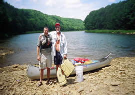
Daybreak was cold for June, thirty nine degrees. I was shivering by daybreak; I had packed my summer sleeping bag, a 50 degree rating. The tent was considerably warmer than the surrounding air. Mist was coming off the water, leaving the river with an eerie glow. The sun's rays were shining fifty feet above us; the sun had not risen yet above the eastern ridge. In an effort to warm up, I started a fire while John cooked breakfast. On our menu for breakfast each morning was coffee and oatmeal, lunch was canned soup or stew with apples and cookies for dessert, and dinner we splurged on three course meals high in carbs.
While eating breakfast, we checked our location on the maps. Usually when paddling a river there are several clues to one's location such as a bridge, islands or side streams. We had yet to see a bridge and last evening we had been caught up in finding a campsite that we missed any other signs. We estimated that we traveled sixteen to eighteen miles. That put us several miles above Keating and Moshannon Falls. After breakfast, I hastily packed my gear and we loaded the canoe.
Moshannon Falls offers the only true class III rapid on our journey. Reading the guide maps, on river left there will be a railroad tunnel a quarter mile above the rapid. The rail line had accompanied us on the northern shore since our put in. We were to land the boat and scout the rapid. The rapid is run by entering the center line and then paddling hard to river right.
The sun was just reaching the river banks when we put in for the day. We didn't have much of a goal, just paddle as far as we could, and when it got close to supper time, and find a campsite for the night. For the most part, the river meandered through state park and state game lands
Paddling was made easy with the wind to our backs, and then made more difficult with the wind to our faces. The river continued to move at a quick pace, offering small rapids and riffles. John and I chatted a bit about how we slept and the cold weather for June. I am not much of a morning person so our conversation slowly died off. In just one day, we were working as a team, our paddle strokes synchronized for greatest efficiency.
John broke the silence and asked if I could see the railroad, I didn't but did glance downstream fifty yards. We were on river left, in a channel bounded by boulders and small hydraulics. I quickly yelled to John that we were heading straight towards a pair of rocks. I was waiting for a response for what side to paddle on to avoid them, but the water's speed and power increased too quickly for a response. We were thrown from our canoe upon impact. Our canoe was swamped and moving on with out us. We scrambled and grabbed the gunnels halting the Grumman's progress. Once a canoe gains water, it becomes nearly immovable. I looked downstream and realized I was between the canoe and rocks, and needed to get situated on the upstream side of the canoe so I wouldn't become crushed. While moving around the canoe, we realized that we were in Mashanon Falls, on the wrong side of the river.
We pulled the canoe into the eddy behind the rock that tipped us and evaluated the situation. Most importantly, we were not injured, the canoe was filled with water, and we were surrounded by fast moving currents bearing down on both sides of us. Looking directly downstream, more rocks and hydraulics, on extreme river right we were offered a line to paddle through the rest of the rapid. John suggested bailing the canoe; I suggested that I swim across the rapid on river left, secure a rope to the canoe and swing John and the canoe around to shore. We bailed the canoe.
We used our hats as bailers, taking out much of the water. The cold air and water was quickly draining my energy. Our plan was to quickly get back in the canoe, get into the center channel and then paddle to the right. We got back into the canoe and began to paddle the rest of the rapid. Miraculously, every stroke and every lean was perfect. We were traversing the worst of the white water and making headway to the right. At the end of the rapid we landed the canoe on a soft sandy shore, exhausted. We emptied the canoe, laying our gear out to drain and dry. Our energy recovered and we replayed the affair to each other.
We reloaded the canoe and continued. The river made great turns around the mountains, the sun warming us on the southern turns and the wind chilling us on the northern turns. We soon passed under the bridge at Keating, our first town since starting 22 miles earlier. The river flattened, deepened and widened. Paddling became laborious with the wind at our faces; I began to paddle slightly bent over to reduce the air resistance. After an hour, the river again turned bringing back its former gradient and rocks.
We ate our lunch across the river from an abandoned mill. Our canned lunch of unheated soup and fruit was welcomed after a morning of paddling. As we began to gather our gear for the rest of the day, we encountered a young beaver swimming along the shore. The yearling had swum under our canoe and was making its way upstream. This was the first sign of wildlife, giving me hope that the river could support life.
After lunch, we continued our paddle downstream. We passed several streams streaking the river sulfuric yellow. The mines had closed decades ago but the toxic remnants remain. The river meandered along the mountain chain; the water had cut into the earth forming the waterway millenniums ago. John and I conversed quietly along the riffles, listening to each stories of each other's spouses, travels, childhood and children.
Late in the afternoon, we paddled into a stretch of area which on one shore was private property and the other was a posted wilderness area which prohibits camping. We rested and looked at the guide maps. We were paddling about ten miles farther than the twenty five miles per day that we had planned. This placed our second night in the middle of a no camping zone. I was concerned but knew that things would work out. I often find myself in a quandary and have faith that things will turn out well.
By now it was past dinner. John and I keep an eye out for possible campsites, but found nothing. We spotted some locals on an embankment enjoying the Sunday evening under a pavilion. From our boat we yelled up to them asking for advice on possible campsites, they knew of none, but suggested there might be a site at the next stream; the other possibility would be the graveyard on the state game lands. Both seemed impractical, but we thanked the couple and began to head downstream.
As we were pushing off the shore, the couple yelled to us to come up for a drink. We took them up on their offer and climbed up the embankment. The couple introduced themselves as Mike and Kay and offered us a beer. I was more interested in the water cooler, as I was beginning to dehydrate from the sun’s exposure. We told them of our journey and intent on reaching the main stem of the Susquehanna.
Kay told us of the raft reproductions that had gone through last spring. I did not follow her story but smiled along. From a whitewater background, I would not need a rubber raft or desire to paddle such a cumbersome craft on a tame river. As Kay continued, I realized the rafts she spoke of were reproduction log rafts from the logging era. Farmers would clear-cut the forest in the winter, sending logs down an iced flume onto the frozen river. During the spring thaw, the logs were marked and tied together forming rafts. The log rafts were floated downstream to Lock Haven, Williamsport and as far south to Marietta, by my home.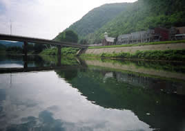
As the sun sank lower, John and I looked at each other, knowing that we still needed to find a place to stay for the evening. As we were heading down, I swallowed a bit of my pride and asked Mike if we could camp on the shoreline below. He thought for a bit, and agreed; John and I had a campsite for the night.